Table of Contents

Parks and open space plans are intended to guide a systematic approach for communities to provide and preserve parks, undeveloped lands, and recreation services for the public good. While all comprehensive plans adopted by Colorado communities are required to include a recreation and tourism element, many choose to develop a separate, complementary parks and open space plan that includes more detailed information. Parks and open space resources within a community may include natural, scenic, cultural, historic, and recreational features or amenities. While such resources often are dispersed, communities increasingly are attempting to build interconnected park and open space systems linked by trails, greenways, or other public corridors.
Much like any other planning document, parks and open space plans vary widely in terms of format, organization, and level of detail, based on the goals of the jurisdiction and the resources available to support the planning effort. Most parks and open space plans contain the following components, or some variation:
- Inventory of assets – What is the current total amount of parks, open spaces, trails, and recreation areas and facilities? Where are they located? Where are there gaps in the system? Are assets located in hazard areas?
- Policies – How should the community address issues related to parks and open space? Should additional investments and land acquisitions occur outside of hazard areas? Is increased maintenance a priority? Should the community consider sharing resources?
- Priorities and recommendations – What are the specific steps a community can take to address a stated issue? Are there gaps in the system that should be treated as priorities? Should areas outside known hazard areas be given higher priority than others?
The Colorado Springs Park System Master Plan includes an entire page of recommendations to address floods, fires, and drought, including:
- Develop fire mitigation partnerships and create natural area management plans with land managers, utility providers, public safety officials and State Parks representatives.
- Work with natural resource managers of wildlife habitat to balance wildlife needs with management for fire, floods, and drought.
- Refer to the [drainage and stream buffer standards or guidelines] for recommendations regarding floodplain treatments, vegetation management, stream bank stabilization, and other elements that mitigate flood events.
- Provide education and enforcement to address unintentional forest fire starts and arson.
- Form stormwater, floodplain, and vegetation management partnerships with flood control districts, watershed managers, City and County public works departments, ditch companies, and other land managers.
- Install more drought-tolerant plant materials and reduce park dependency on water resources.
- Identify and re-route trails that are susceptible to frequent damage from flooding.
By preparing and maintaining a parks and open space plan, communities will clearly articulate their commitment and strategy to preserving and enhancing specific assets or lands that serve multiple purposes. Primary benefits include:
- Serves as a powerful project implementation tool for hazard mitigation or avoidance – especially with regard to competing land development interests.
- Promotes multi-objective planning for parks and open space properties that intersect with hazard areas.
- Can complement and provide more robust analysis and information on parks and open space than found in the community’s comprehensive or master plan.
- Specific policy statements and pre-identified parks and open space projects that promote public safety can support more creative and competitive applications for grant funding.
- A parks and open space plan can set the policy foundation for a land acquisition and/or Transfer of Development Rights (TDR) program.
The development of parks and open space plans, as well as integrating hazard considerations into such plans, requires dedicated trained staff time or funding to hire a consultant. Other related challenges include:
- Can be challenging to implement or administer without dedicated parks planning staff.
- Some technical mapping and analysis of hazard areas may be required.
- Funding for plan implementation activities may be inadequate or difficult to obtain, particularly for the acquisition of private, developable properties.
- Plans should be updated and maintained on a regular basis, concurrent with comprehensive or master plan updates, and perhaps even more frequently for communities experiencing rapid changes through growth and land development.
- The timing of the preparation of parks and open space plans may not overlap with the development of a hazard mitigation plan. This means planners must make a concerted effort to promote coordination between the goals, policies, and actions of both efforts, as well as other related plans.
Administrative Capacity
Planner, parks and recreation staff
Mapping
Some technical mapping and GIS analysis may be required for integrating hazard areas and to support the supply inventory, demand assessment, or surplus/deficiency analysis
Regulatory Requirements
None required, but can support plan implementation
Maintenance
Should be updated at a regular time interval, preferably every five years
Adoption Required
Yes
Statutory Reference
N/A
Associated Costs
Staff time, plus potential costs for mapping or other technical work, public outreach activities, and consultant services
Examples of the Tool
Town of Basalt Parks, Open Space, and Trails Master Plan
City of Colorado Springs Parks System Master Plan
Douglas County 2030 Parks, Trails, and Open Space Master Plan
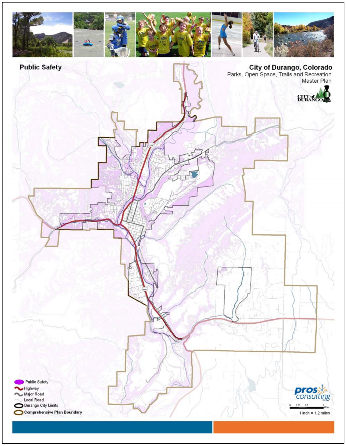
City of Durango Parks, Open Space, Trails, and Recreation Master Plan
Town of Erie Parks, Recreation, Open Space, and Trails Master Plan
City of Fort Collins Natural Areas Master Plan
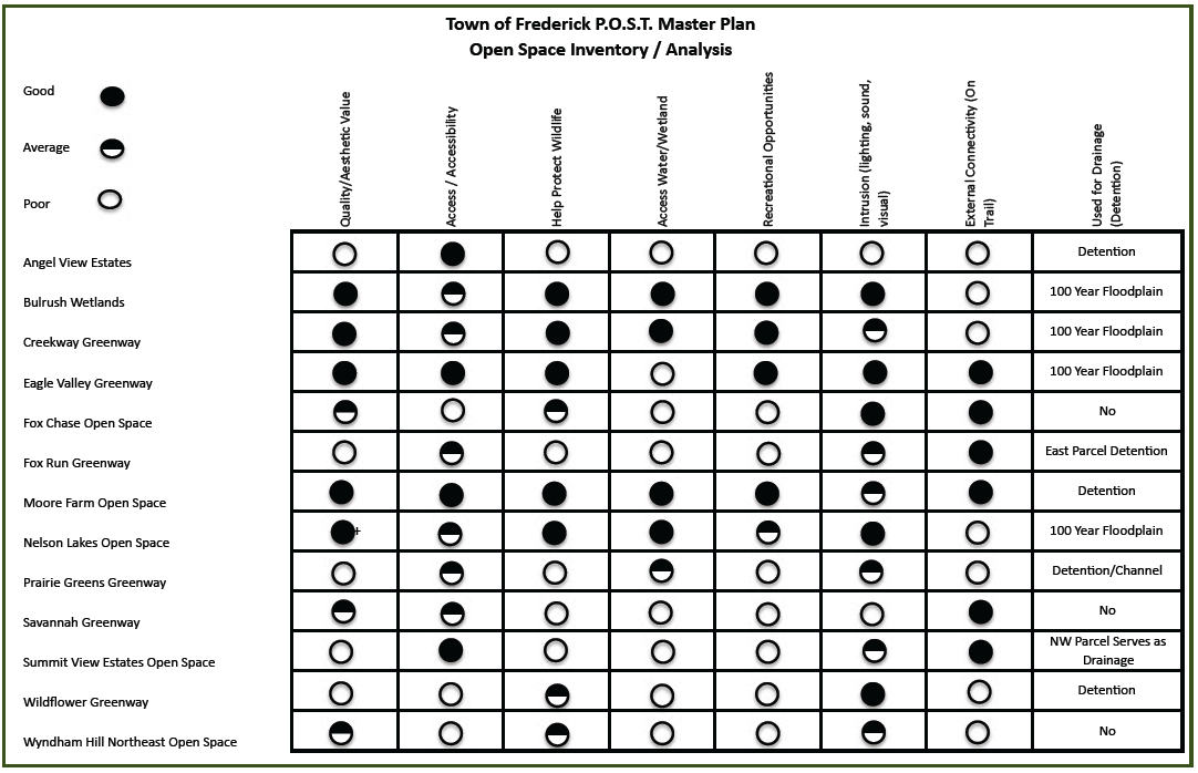
Town of Frederick Parks, Open Space, and Trails Master Plan
Jefferson County Open Space Master Plan
Johnstown/Milliken Parks, Trails, Recreation, Open Space Master Plan
For More Information
Colorado Department of Local Affairs, Conservation Trust Fund Website